Skip to content
Architecture, urban planning and research in, on and next to water
+31 70 39 44 234     info@waterstudio.nl

Floating future

TOPOS, Koen Olthuis

Given the ongoing trend of urbanisation and the unpredictable effects of climate change, architects and urban planners need to rethink the way they deal with water in the built environment’, says Koen Olthuis of Waterstudio.NL, an architectural firm based in Rijswijk, the Netherlands, that has taken up the challenge of developing solutions to the problems posed by urbanization and climate change. Waterstudio.NL thinks that large scale floating urbanism will provide a sustainable strategy that is able to deal flexibly with changing demands while being able to adapt to water level fluctuations. Between now and the future they envision four steps towards utilising the full potential of floating developments. Leading Waterstudio.NL is Koen Olthuis, who studied Architecture and Industrial design at the Delft University of Technology. In 2007, he was chosen as nr. 122 on the Time Magazine list of most influential people in the world. His vision is to change cities worldwide by using water as building ground.

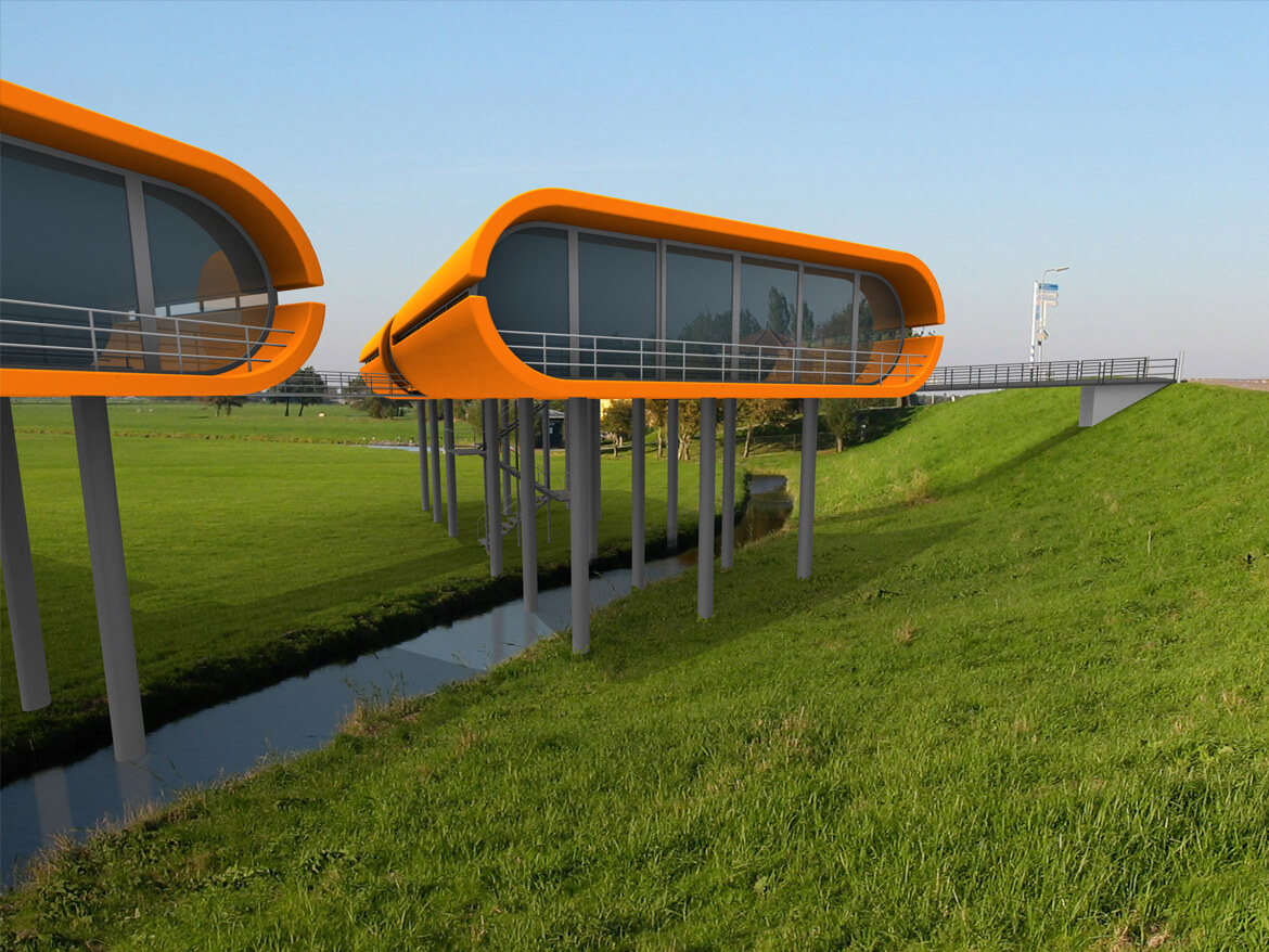
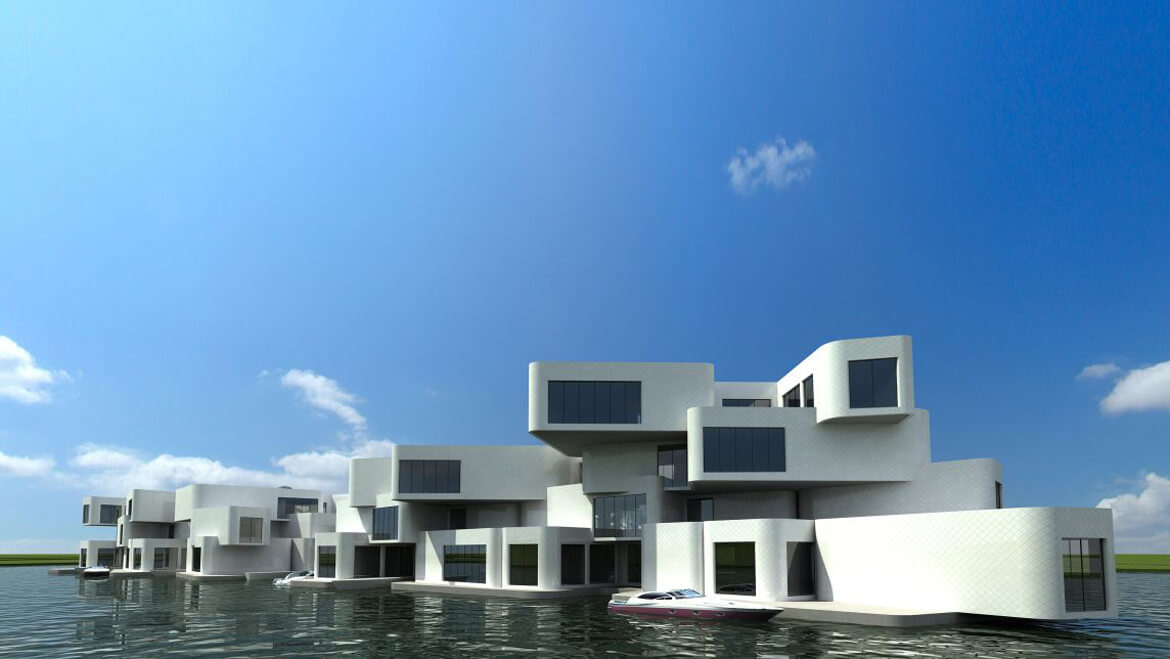
The current generation of architects belongs to the ‘climate change generation’. It is up to young architects to think of solutions to the consequences of climate change in our urban environment and think about the cities of tomorrow. For the first time in history, more people worldwide are now living in urban areas than in the country. Migration to the city continues unabated. Prognoses are that by 2050 70% of the world’s population will live in urbanized areas. Given the fact that about 90% of the world’s largest cities are situated at the waterfront, we are forced to rethink the way we live with water in the built environment. Given the unpredictability of future developments we need to come up with flexible strategies – planning for change. Since infrastructural efficiency puts a limit on simple expansion, we need to find density within existing metropoles: this new density can be found by making use of the existing water in the urban landscape. Where urban planners run into problems by the limits of space and the rise of sea levels, the freedom of floating developments on water only takes off! Water is the next big thing. In our scenario for the future, we’ve distinguished four steps towards floating urbanism. The stepping stone for these developments is to close the gap between land and water houses, by making water houses equivalent to traditional houses on land, in all relevant aspects such as comfort, quality and price. 2010-2020: Trading Places Economic pressure and ground prices in city centres often demand that old functions are demolished. The coming 10 years the first step in water-based development is to relocate functions, which claim a large amount of space in economically valuable areas while generating low revenues, from the centre to the waterfront. This provides space for more economically feasible developments in expensive high-density areas while regenerating often dilapidated waterfronts. We call this ‘trading places’. 2020 – Future: expanding urban fabric A next step would be to expand the urban fabric beyond the waterfront: building normal urban configurations on water locations, with normal densities and all the usual typologies. Water-based neighbourhoods that look and feel just like traditional land-based areas, but only happen to have a floating foundation that allows them to cope with water fluctuations. Logical places to start expanding the urban fabric beyond the waterfront are the old harbours, where a lot of space can be found close to the centre and where square meter prices are lower than in the centre.

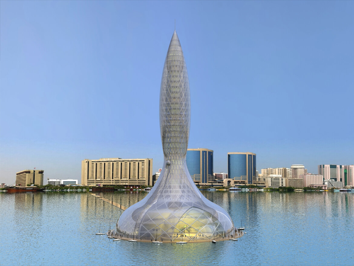
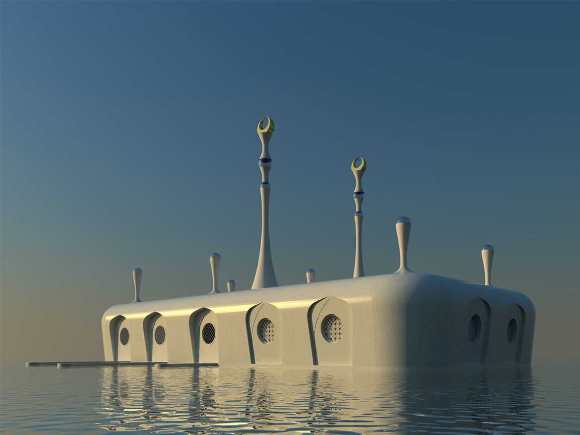
2040 – Future: dynamic cities The following step would be that buildings in the course of time could be relocated according to changing conditions. Cities will be made up of dynamic constellations, in which functions can be moved during their lifetime, responding to both social needs as well as economical considerations. By uncoupling the permanent connection between building and location, the building becomes a commodity – a product that can be used during its lifetime by different owners at different locations. This reduces the double costs of demolition and rebuilding, resulting in both economic as well as resource savings on an unprecedented scale. 2100 : Consumer urbanism In the long term, changes in urban conditions and demands happen not only within cities, but also on a global scale between different cities. Some metropoles may expand quicker than others, while their functional makeup may change. The identity of major cities, their character, resides in the centre that is least affected by growth and shrinkage. The suburbs represent more temporary functional additions that help the town as a whole to function. These suburbs are interchangeable between cities. Floating city parts allow a site to be used for different purposes in the course of time, by relocating functions without leaving a trace – the temporary use of space leaves no permanent damage to the location, making it a sustainable strategy. Floating city parts allow the emergence of what we call consumer urbanism: the scarless relocation of city parts to another city, able to respond to changing requirements in a global market for urban components. It is neither technology nor money that keeps floating developments from being realized yet on a large scale, but the lack of a change in perceptions. Climate effects, together with the pressure on space through urbanisation, will push our design targets beyond the waterfront. By introducing new innovative concepts and visions we can achieve sustainable architectural, urban, social and environmental results while dealing with water management problems at the same time. A sustainable future lies beyond the waterfront! It is up to the climate change generation now

Click here for the full article

Living on estate agents’ water

Topos Architecture and Landscape, Hans Venhuizen

01-12-2006, Topos

AT FIRST GLANCE it might not strike you, but many Dutch people live in the midst of a treacherous landscape. The story of the Dutch reclaiming their country from the sea is a familiar tale, but the fact that they are now well on their way to returning the land to that very same sea is something new, even for the majority of Dutch people. The increase in flooding because of climate change is, of course, the outcome of human behaviour, but that is not what I mean; in general, the dikes here still fulfil their protective task. The danger lies in the land behind the dikes, the polders, which are subsiding ever further because of urbanization and highly effective water management systems. Architecture and urban development are increasingly capitalizing on this, by coincidence but also intentionally.

Until the 1960s, the dynamism of water was a natural fact. When building a house in an area that might be flooded you laid flagstones in your living room instead of a parquet floor. If the water rose then you moved the furniture to the first floor and went to lodge with family elsewhere. Once the water level had fallen you scrubbed the floors and put the furniture back in its place. Since the 1960s, the faith in our technical ability to control water has been growing, and as a result we have become less and less concerned about the sites used for construction. The state secretary still actually considers it a ‘tremendous challenge’ to build at the lowest point in the Netherlands, which is about six metres below sea level. It is our heart’s desire to live overlooking water, and to achieve this we are all too happy to re-excavate previously filled-in urban canals. The water is an enemy that has become a friend, and our understanding of the true dynamism of water and its perceived image have become increasingly estranged.

Thanks to our engineering acuity it was possible to construct part of the Randstad urban conurbation on the waterlogged soil of a former morass. Houses are built on piles that sometimes have to be driven to a depth of thirty metres in order to reach the solidity of the sand layer beneath the peat, a substratum that will no longer subside. However, that is prohibitively expensive for roadways, footpaths, parks and gardens, which are subsequently lain on a layer of sand that is a ‘mere’ metre or two deep. A layer like this stabilizes the unstable topsoil a little and, at least on completion, looks very trustworthy. However, this semblance of stability leads to absurd situations. Any weight that rests on the unstable soil compresses it, and pumping off water, made necessary by the situation below sea level, lends a helping hand. With every new layer of sand that is added to keep houses accessible the ground subsides even faster. It is a process that is unstoppable. In the city of Gouda, midway halfway between Utrecht and Rotterdam, there are roads that people suspect are now between 8 and 12 metres thick. Layer upon layer of asphalt has been added on top of the roads that are sinking into the peat in order to maintain them at surface level and to make them appear stable. This fixation on the superficial pretence of stability typifies many of today’s trends in spatial planning and water management

In many new residential districts, the soggy ground is hardly even taken into account. The engineers simply spray on a two-metre layer of sand in order to stabilize the watery and unstable subsoil, whereupon construction can begin. By a circuitous route, that water has recently started to find its way back to the surface. In order to gain the confidence of the homebuyer, developers make every effort to imbue the new residential areas with individuality, authenticity and identity. Oddly enough, this identity is not sought in the landscape in the midst of which the property is being built – in any case, that landscape has been completely eradicated by the addition of a layer of sand – but is usually conceived afterwards. After all the problems of development, land parcellation, infrastructure and water management have been solved, it is time to consider identity. Then the landscape-related elements or the location’s original qualities can be reintroduced, but in a manageable and symbolic manner. And ‘water’ is then seized upon enthusiastically at places where it in fact plays a much more essential role, as at the VINEX development site of Carnisselanden near Barendrecht, just south of Rotterdam. The ‘soundings’ to determine the soil quality here were not quite sufficiently detailed to gain a true impression of the former marshland. The geological survey therefore confused the traces of an old creek with a thick layer of peat. And as a result of the creek’s layer of ‘thick water’, the sewers that were installed on Friday had already sunk to an undetectable depth by Monday. Later on, at the same site as the ‘disappearing’ sewers, a series of ‘lighthouse dwellings’ was realized, giving the spot a readily marketable identity and reflecting the connection with water. This relationship was initially left unacknowledged, then combatted, and ultimately represented in a ridiculous way.

This example demonstrates that in the quest for identity its most important vectors are often missed. These ‘bearers’ of identity have for a very long time been the specific limitations of a site within which a particular development ambition has to be conceived and realized. For centuries, limitations were the most effective shapers of our ambitions and therefore prescribed our built identity. Nowadays we resolve the limitations using technical means and contrive an identity afterwards. To this end, it is often the icons that have evolved over time that are copied, such as lighthouse dwellings, typical dike and bridge houses or windmills, but we fail to develop new icons. Proceeding from this idea, I devised the ‘Amphibious Living’ project in 2000, a project that generated many potential new icons for settlement and for water.

No more than a decade ago, you could receive a premium from Gouda City Council if you abandoned your houseboat and allowed it to be demolished. Houseboats were then still subject to the municipality’s legislation on slum dwellings. Even a city like Amsterdam has never been truly happy with the houseboats lining its canals. They certainly provide picturesque photo opportunities, but they are an untidy eyesore amid the cityscape, they constitute a safety risk and they discharge sewage directly into the canal. Houseboats were legally considered to be moveable property and were therefore ineligible for a mortgage or for rent subsidy. It was usually DIY adventurers who made their home on the water. However, this policy shifted about five years ago. Alongside increasing prosperity and liberalization of the housing market this was primarily driven by the abovementioned quest for identity in the built environment. Living alongside water had been a guaranteed sales hit for a long time already, but living on water was now deemed worthy of a mortgage as well.

In more and more expansion plans, plots are being reserved for floating dwellings in developments with overblown names such as ‘Water Gardens’, ‘Blue City’ or ‘Gold Coast’. The lakes and canals in these newly built neighbourhoods are also mockingly called ‘estate agent’s water’. Thanks to the introduction of tailor-made mortgages and to a number of ‘water villas’ being realized by respected architects such as Herman Hertzberger and Art Zaaijer, living on water has transcended the world of adventurers and odd-jobbers and has become socially desirable. This goes hand in hand with the image of freedom and independence that is associated with living on water. The floating dwellings can be turned to face the sun or even moved to a completely different location. The reality is different, of course, because the plots are usually so confined that there is not much chance of being able to turn, and the dwellings are generally fitted with every modern convenience and are therefore wholly dependent on the umbilical cord of mains and amenities at their moorings. These mooring places are limited in number, so the dwelling cannot be tied up anywhere, to say nothing of the often insurmountable obstacles such as bridges and dikes that the dwelling would encounter en route from one berth to another. The freedom and independence of the marketing brochures therefore rely on suggestion, but that is precisely the level at which they work best. The inhabitants of floating dwellings are generally very fond of their comfort and security. They are primarily seeking the image of independence and the sense of freedom without having to suffer the negative consequences.

For the housing market, the quest to distinctively combine human settlement and water has become a welcome and rewarding theme. Architecture bureaus with names such as Aquatecture and Waterstudio are capitalizing on this trend and present their concept dwellings in catalogues. Living with water has become a commodity to be reckoned with, for which water is even artificially created. In the economically weak region of East Groningen, in the north of the Netherlands, a public-private partnership is developing an 800-hectare expanse of agricultural land that has been re-flooded in order to establish an ideal residential and recreational environment. This project also draws on the positive identity of water: as a bringer of peace and quiet, an element that creates space, a recreational lake and a mirror for the architecture.

Now it is the government that is starting to develop an eye for the identity-imbuing power of water. A body of water is not only the surface, but also has a bottom. The use of agricultural pesticides over the decades has resulted in the accumulation of highly polluted sludge at the bottom of expanses of water and waterways. Intriguing alternatives have been devised for the expensive process of dredging up and transporting this polluted sludge. Sealing the dredged-up sludge in containers and using these to raise traditional ‘terps’ (mounds historically constructed to provide a safe human settlement) in areas prone to flooding would generate identity that springs from solving a problem.

Experiments in river forelands have also been promoted recently. In the knowledge that total water management is no longer feasible, the government has commissioned research into how human settlement and unstable water levels might be reconciled. The river forelands are the ideal testing ground for this. Inadvertently, the many luxurious floating villas on the quiet and stable recreational lakes will then be best prepared for that prospective instability or deluge. And then their inhabitants can at last truly put into practice the image of freedom and independence to which they aspire.

Click here to read the article

Click here for the website

Back To Top
Search